
Typhoon Gorio Intensifies, Threatens Northern Philippines with Heavy Rain
Typhoon Gorio intensifies near Batanes with 130 km/h winds, bringing heavy rainfall to northern Philippines. PAGASA raises warning levels as the storm moves toward Taiwan.
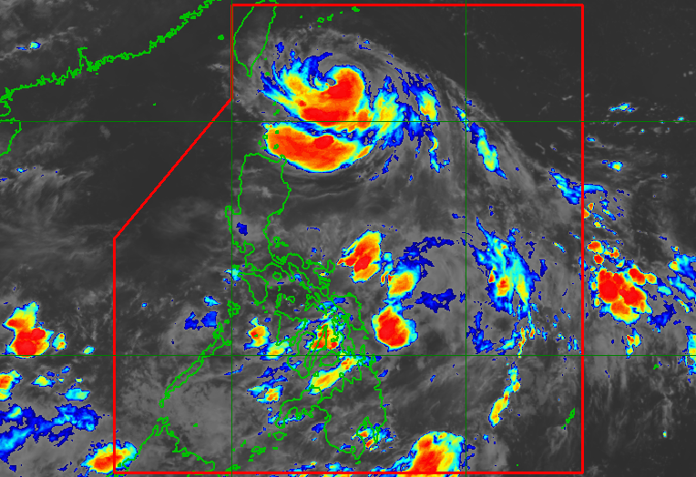
Satellite image of Typhoon Gorio approaching northern Philippines with visible rain bands affecting Batanes and Cagayan regions
Typhoon Gorio Gains Strength Near Batanes
Typhoon Gorio (Podul) has intensified Tuesday evening, with maximum sustained winds increasing to 130 kilometers per hour, up from its previous 120 km/h, as it moves westward toward Taiwan through the Philippine Area of Responsibility (PAR).
The Philippine Atmospheric, Geophysical, and Astronomical Services Administration (PAGASA) reported in its 11 pm bulletin that the typhoon, located 300 kilometers east northeast of Itbayat, Batanes, now packs stronger gustiness of up to 160 km/h.
Impact on Northern Philippines
While the northern regions of the Philippines face increasing weather challenges, moderate to heavy rainfall is affecting both Batanes and Cagayan provinces, raising concerns about potential floods and landslides.
PAGASA has elevated the warning level to Signal No. 2 for Itbayat municipality in Batanes, indicating the presence of gale-force winds. The rest of Batanes remains under Signal No. 1, with strong winds expected to persist.
Maritime and Coastal Warnings
As weather systems continue to impact the Philippines, authorities have issued gale warnings for extreme Northern Luzon's seaboard. While no storm surge alerts are currently in place, PAGASA warns of potential coastal flooding due to high waves, particularly if the typhoon's track shifts southward.
Regional Weather Impact
The southwest monsoon is expected to bring scattered rain showers and thunderstorms to various regions, including parts of Mindoro, Palawan, and several areas in Mindanao. The rest of the country will experience generally fair weather with isolated thunderstorms.
Gorio is projected to make landfall in Taiwan by Wednesday morning or afternoon, August 13, before exiting PAR later that day, marking the country's seventh tropical cyclone for 2025.
Manny Pacquiao
Independent Filipino journalist covering democracy, civil rights, and government accountability across Southeast Asia.